|
www.terrasat.de
|
GeoGenius 2000 - Stichting Modula - Date : 27-APR-02 Time : 22:07:20 |
| Baseline: |
DELFT |
to |
Garmin |
| File, Point, Code |
DELF1140.OBS |
DELFT |
13502M004 |
| Receiver, Version, S/N |
TRIMBLE 4700 |
1.20 |
0220196517 |
| Antenna type, S/N |
TRM29659.00 UNA | 0220193258 |
| Geocentric Position [m] |
3924687.7080 |
301132.7690 |
5001910.7700 |
| Instr. height ecc. (N,E,H) [m] |
0.0000 |
0.0000 |
0.0000 |
| Week, Day, Date |
1163 |
114 |
24-APR-2002 |
| Start, End, Interval |
291600.00 |
298770.00 |
30.00 |
| Code indicators |
C/A |
P2 |
P1 |
| Carrier indicators |
P1 |
Y1-Y2 |
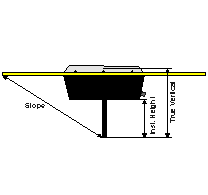
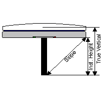
Phase Center Offsets:
| Description |
Value |
Unit |
| Correction Factor (a) |
0.0 |
[mm] |
| Horizontal Offset (b) |
0.0 |
[mm] |
| Phase Center Offset L1 (c1) |
0.0 |
[mm] |
| Phase Center Offset L2 (c2) |
0.0 |
[mm] |

2. |
Corrected Instrument Eccentricities |
| Session |
North [m] |
East [m] |
Height [m] |
| 1 |
0.0000 |
0.0000 |
0.0000 |
| System |
SVID |
Observations |
| GPS |
2 |
240 |
| GPS |
3 |
240 |
| GPS |
6 |
110 |
| GPS |
8 |
119 |
| GPS |
10 |
58 |
| GPS |
15 |
240 |
| GPS |
17 |
240 |
| GPS |
21 |
240 |
| GPS |
22 |
240 |
| GPS |
23 |
240 |
| GPS |
25 |
35 |
| GPS |
26 |
157 |
| GPS |
27 |
239 |
| GPS |
29 |
97 |
| GPS |
31 |
210 |
| File, Point, Code |
DAK21144.OBS |
Garmin |
Number of Antenn |
| Receiver, Version, S/N |
GPS 12 SOFTWARE 4 |
4.58 |
087 |
| Antenna type, S/N |
GPS12 Internal Ante | |
| Geocentric Position [m] |
3914066.2196 |
314686.0048 |
5009302.5006 |
| Instr. height ecc. (N,E,H) [m] |
0.0000 |
0.0000 |
0.0000 |
| Week, Day, Date |
1163 |
114 |
24-APR-2002 |
| Start, End, Interval |
292657.00 |
297317.09 |
1.00 |
| Code indicators |
C/A |
| Carrier indicators |
P1 |
Phase Center Offsets:
| Description |
Value |
Unit |
| Correction Factor (a) |
27.0 |
[mm] |
| Horizontal Offset (b) |
112.0 |
[mm] |
| Phase Center Offset L1 (c1) |
0.0 |
[mm] |
| Phase Center Offset L2 (c2) |
0.0 |
[mm] |

5. |
Corrected Instrument Eccentricities |
| Session |
North [m] |
East [m] |
Height [m] |
| 1 |
0.0000 |
0.0000 |
0.0270 |
| System |
SVID |
Observations |
| GPS |
2 |
4639 |
| GPS |
3 |
4635 |
| GPS |
6 |
2120 |
| GPS |
8 |
1049 |
| GPS |
10 |
498 |
| GPS |
15 |
4639 |
| GPS |
17 |
4639 |
| GPS |
18 |
4632 |
| GPS |
21 |
4610 |
| GPS |
22 |
4639 |
| GPS |
23 |
4637 |
| GPS |
25 |
200 |
| GPS |
26 |
2655 |
| GPS |
27 |
2289 |
| GPS |
29 |
1405 |
| WARNING: (CNTLIN)-W-DISABLING L2 NOW - CONTINUING WITH L1 ONLY |
ALL TIMES ARE GIVEN IN GPS + 2.00 HOURS
TROPOSPHERIC MODEL: MODIFIED HOPFIELD WITH FIXED MET DATA
REFERENCE: 293 K 1013 hPa 50 % - MEASURED AT 0 0 0 M
ROVER : 293 K 1013 hPa 50 % - MEASURED AT 0 0 0 M
MINIMUM SNR : 30 30
DUAL-FREQ. AMBIGUITY SEARCH : YES
OBSERVATION EDIT MULTIPLIER : 3.5
RELATIVE IONOSPHERIC ERROR : 2.0 PPM
RELATIVE EPHEMERIS ERROR : 1.0 PPM
START TIME : 292650.0(11:17:30.00)END TIME : 297330.5(12:35:30.00)
INTERVAL : 30.00 CUTOFF GPS/GLN : 10/ 15 FREQUENCY : L1
8. |
Number of Single Differences |
| System |
SVID |
Observ. |
Min_El |
Max_El |
Min_Snr1 |
Max_Snr1 |
Comment |
| GPS |
2 |
152 |
54 |
60 |
47 |
50 |
| GPS |
3 |
152 |
43 |
77 |
45 |
50 |
| GPS |
6 |
25 |
1 |
15 |
40 |
50 |
| GPS |
15 |
151 |
43 |
73 |
47 |
50 |
| GPS |
17 |
151 |
29 |
61 |
45 |
50 |
| GPS |
21 |
147 |
12 |
45 |
42 |
47 |
| GPS |
22 |
151 |
37 |
68 |
45 |
50 |
| GPS |
23 |
150 |
14 |
30 |
42 |
50 |
| GPS |
27 |
34 |
8 |
15 |
40 |
45 |
GPS 2 <-- Reference Satellite - Total No. of Observations : 1113
9. |
Satellite Availability |
| System |
SVID |
Start Date & Start Time |
Stop Date & Stop Time |
| GPS |
2 |
24-APR-2002 11:18:00.00 |
24-APR-2002 12:35:00.00 |
| GPS |
3 |
24-APR-2002 11:18:00.00 |
24-APR-2002 12:35:00.00 |
| GPS |
6 |
24-APR-2002 11:18:00.00 |
24-APR-2002 11:32:00.00 |
| GPS |
15 |
24-APR-2002 11:18:00.00 |
24-APR-2002 12:35:00.00 |
| GPS |
17 |
24-APR-2002 11:18:00.00 |
24-APR-2002 12:35:00.00 |
| GPS |
21 |
24-APR-2002 11:18:00.00 |
24-APR-2002 12:35:00.00 |
| GPS |
22 |
24-APR-2002 11:18:00.00 |
24-APR-2002 12:35:00.00 |
| GPS |
23 |
24-APR-2002 11:18:00.00 |
24-APR-2002 12:35:00.00 |
| GPS |
27 |
24-APR-2002 11:26:30.00 |
24-APR-2002 12:33:00.00 |
10. |
Number of Rejected Observations |
| System |
SVID |
Elev |
SNR |
Marked |
Losses of Lock |
| GPS |
6 |
45 |
0 |
0 |
5 |
| GPS |
8 |
67 |
0 |
0 |
3 |
| GPS |
10 |
22 |
0 |
0 |
3 |
| GPS |
17 |
0 |
0 |
0 |
1 |
| GPS |
18 |
0 |
0 |
0 |
1 |
| GPS |
21 |
0 |
0 |
0 |
5 |
| GPS |
22 |
0 |
0 |
0 |
1 |
| GPS |
23 |
0 |
0 |
0 |
2 |
| GPS |
25 |
0 |
0 |
0 |
3 |
| GPS |
26 |
104 |
0 |
0 |
8 |
| GPS |
27 |
15 |
0 |
0 |
31 |
| GPS |
29 |
48 |
0 |
0 |
1 |
11. |
Triple Difference Solution |
ITERATION 1 : POSITION SHIFTS DX DY DZ [m] = 0.039 0.086 -0.013
ITERATION 2 : POSITION SHIFTS DX DY DZ [m] = 0.000 0.000 0.000
12. |
Number of Cycle Slips |
| System |
SVID |
Cycle Slips |
| GPS |
3 |
2 |
| GPS |
6 |
1 |
| GPS |
22 |
1 |
13. |
Cycle Slip Summary for L1 |
| System |
SVID |
Time in Sec. |
HH:MM:SS |
Cycle Slip [cycles] |
Sigma [cyc] |
Recovery Comment |
| GPS |
6 |
293010.01 |
11:23:30.00 |
-12.052 |
0.005 |
RECOVERED |
| GPS |
22 |
293250.01 |
11:27:30.00 |
-2.996 |
0.001 |
RECOVERED |
| GPS |
3 |
293310.01 |
11:28:30.00 |
-1.993 |
0.002 |
RECOVERED |
| GPS |
3 |
293370.02 |
11:29:30.00 |
1.045 |
0.002 |
RECOVERED |
Triple Difference Baseline Components
| Freq |
dX [m] |
dY [m] |
dZ [m] |
sX [mm] |
sY [mm] |
sZ [mm] |
rms [mm] |
| L1 |
-10621.5278 |
13553.1494 |
7391.7432 |
66.5 |
150.5 |
86.9 |
7.3 |
14. |
Double Difference Solution |
GPS SATELLITE 27 ARC 1 11:26:30.00- 12:33:00.00 DELETED FROM PROCESSING DUE TO LITTLE DATA
Double Difference Float Baseline Components
| Freq |
dX [m] |
dY [m] |
dZ [m] |
sX [mm] |
sY [mm] |
sZ [mm] |
rms [mm] |
| L1 |
-10621.4884 |
13553.2358 |
7391.7306 |
5.1 |
10.5 |
6.4 |
11.8 |
15. |
Determined Ambiguities |
| System |
SVID |
Arc |
Freq |
Ambiguity [cycles] |
Sigma |
| GPS |
23 |
1 |
L1 |
-12314231.761 |
0.070 |
| GPS |
21 |
1 |
L1 |
-21059420.845 |
0.059 |
| GPS |
15 |
1 |
L1 |
4327483.056 |
0.051 |
| GPS |
6 |
1 |
L1 |
-17160616.890 |
0.112 |
| GPS |
17 |
1 |
L1 |
1809409.552 |
0.060 |
| GPS |
3 |
1 |
L1 |
-5024699.521 |
0.010 |
| GPS |
22 |
1 |
L1 |
-21603517.950 |
0.026 |
Number of integer combinations to check = 27
Use of code measurements disabled due to large errors
16. |
Regression Analysis for L1 |
| System |
SVID |
Arc |
Sig_b[mm] |
Sig_s[mm/s] |
RMS[mm] |
Observ. |
CHI2 |
Probability [%] |
| GPS |
23 |
1 |
5.0 |
0.0019 |
30.7 |
150 |
25.561 |
100.000 |
| GPS |
21 |
1 |
3.4 |
0.0013 |
20.6 |
147 |
11.306 |
100.000 |
| GPS |
15 |
1 |
3.6 |
0.0014 |
22.1 |
151 |
13.364 |
100.000 |
| GPS |
6 |
1 |
4.1 |
0.0082 |
10.6 |
25 |
0.469 |
100.000 |
| GPS |
17 |
1 |
4.3 |
0.0016 |
26.9 |
151 |
19.692 |
100.000 |
| GPS |
3 |
1 |
1.6 |
0.0006 |
10.2 |
152 |
2.850 |
100.000 |
| GPS |
22 |
1 |
1.5 |
0.0006 |
9.4 |
151 |
2.431 |
100.000 |
| WARNING: (AMBFIX)-W-Ambiguity fixing disabled in this version |
| Point, Info, Code |
DELFT |
| 13502M004 |
| Geocentric position |
3924687.7080 |
301132.7690 |
5001910.7700 |
| Lat, Long, Height |
N 51 59 10.02191 |
E 4 23 15.30289 |
74.3593 |
| Point, Info, Code |
Garmin |
| Number of Antenn |
| Geocentric position |
3914066.2196 |
314686.0048 |
5009302.5006 |
| Lat, Long, Height |
N 52 5 40.16235 |
E 4 35 47.83759 |
41.9736 |
| Solution Type, Freq, Quality |
Double Diff Float |
L1 |
Medium |
| DeltaX, DeltaY, DeltaZ |
-10621.4884 |
13553.2358 |
7391.7306 |
| Sigmas (N,E,H) [mm] |
4.4 |
10.6 |
6.8 |
| Sigmas (X,Y,Z) [mm] |
5.1 |
10.5 |
6.4 |
| Correlation Cxy,Cxz,Cyz |
-0.199388 |
0.429885 |
-0.363825 |
| Min & Max PDOP, RDOP |
2.11 |
6.90 |
0.21 |
19. |
Observation Statistics |
| System |
SVID |
Arc |
Number |
RMS [mm] |
Max elev |
| GPS |
23 |
1 |
150 |
30.7 |
31 |
| GPS |
21 |
1 |
147 |
20.6 |
45 |
| GPS |
15 |
1 |
151 |
22.1 |
74 |
| GPS |
6 |
1 |
25 |
10.6 |
15 |
| GPS |
17 |
1 |
151 |
26.9 |
61 |
| GPS |
3 |
1 |
152 |
10.2 |
78 |
| GPS |
22 |
1 |
151 |
9.4 |
69 |


