Use of the RD-grid in your GPS by Prof. Y. Lupardi
.
Basics
The x-coordinate is called Easting (E) and the y-coordinate Northing (N) and both are given in meters mostly. So the position of the centre of the small round island in the Hofvijver in The Hague (seat of gouverment) is noted as 081322E 455215N.
The easting starts at about 012000 and comes nowhere higher than 276000. The northing starts (in ZuidLimburg) with 306000 an ends upnorth with 615000.
So: the number for easting (west-east direction) is always smaller than 300000 and Northing numbers are always bigger then 300000. So you can keep in mind: the highest number of an RD-coordinate goes 'upwards' on the map, to the North that is.
There are many ways to write down these coordinates. Mostly (but not always) first the Easting then the Northing values. Sometimes they are given in kilometers like 81.4 / 455.2 but mostly in meters. Then you have 6 (sometimes 5 when no leading zero is written when easting <100000 ) numbers for the easting and 6 for the northing.
Because in Europe we use the decimal comma and not the point, you will see for positions with millimeter accuracy the notation 123456,789. But because there are no consumer handheld GPS systems with an accuracy of less than 1 meter, this is a moot subject for most people.
But beware: some GPS types make use of a point and display things like 123.456. Then that dot is really used as the European point for 'thousands' units. (Where the British use the comma.)
Some files and programs for use with the RD-grid
If you have a postal code (say 1123 PG) and you want to know where that is: here is a file ( 2745 kb!) you can use in Excel (spreadsheet).
If you want to know where all official (5000+!) points (benchmarks) of the Dutch RD-network are to be found: see here for download (840 kb). You need to have Excel to use them.
If you want to convert between WGS84 and RD with help of your spreadsheet program: see here. (thanks to Ejo Schrama)
Of course there is an official sanctioned transformer between WGS84 and RD. There is a free download of CC41 (with manual) here.
The False Norting question
Most GPSr's are used to count the False Northing for the RD-Grid from the equator.
Then you get numbers like:
False Northing -5316592.0 or about 5317 km.
Sometimes you have to give the Latitude Origin and 90 or 0 degrees are not allowed. Then give
Latitude of origin: 52.15617N
with the False Northing of 00463000.0
The recipes
After asking for information about other types of GPS, many people gave me information. I thank them all. Because the types that have built-in Dutch grids also have the Dutch Language choice, I will give for some types in Dutch what you see on the screen of your GPS.
There are two things to do: set the map-datum and set the representation (RD-coordinates in meters).
Another question that is asked many times concerns the software MapSource: 'How do I to use RD grid?' An answer can be found at the end of this page.
Garmin E-trex Vista
Here it is very simple for you to use the RD-coordinates: they are builtin. So simply do:
Hoofdmenu >>Instellingen >> Eenheden
Here you can make a choice of positieformaat for Ned. RD Grid, mostly called Map Datum Dutch. Different names are in use. Further you have to set: Rijksdriehoeksmeting, RD format or Dutch Grid depending on the software version (and your own language choice).
Garmin GPS 12
The manual of the GPS 12 is very vague about how to set and use the 'User-defined' feature. For the GPS12 (as I have) you do the following:
Goto the MAIN MENU and the last entry there is SETUP MENU. Enter this one and a list appears. The second entry in the list is NAVIGATION.
After an [enter] you are in the navigation setup page where you find:
POSITION FRMT and MAP DATUM and 'Units'. Set the units to 'metric'.
By default the POSITION FRMT is hddd°mm.mmm'. Move the cursor to this and enter. Then you toggle downwards until you arrive at 'User Grid'. Do an [enter] and you find your first page with numbers to fill in.
Longitude origin: E 005°23.258'; Scale: 0.9999079; False E: 155000.0; False N: -5316592.0
Do the 'save'.
Next to do is the Map datum. In the Nav Setup menu goto the MAP DATUM and toggle upwards until 'User' appears. Do an [enter] and you can fill in the USER DATUM dx: 593; dy: 26; dz: 478; da: 740; df: 0.1003748
Important: before you do all this set the 'metric' in the menu 'Navigation'.
There are more gymnastics your GPS 12 is capable of. I have made a small list of al the Garmin GPS12 Secret Codes here For more about other Garmin GPS types see here.
Garmin GPS III
You have to do the same two things: 'Position Format' en 'Map datum' are the names. I give you a step by step.
1) Switch on and press 2x on [Menu] and select Setup in the Main menu. (last of the list).
2) press [Enter] and you get a field with tabs on top. Move the cursor to tab "Position". Then you will see two things: 'Position Format' and 'Map Datum'.First we do the 'Position Format '. Move the [cursor] on it and do an [Enter].
2a) a list pops up and after scrolling down with the cursor you arrive at last at "User UTM Grid". That is the one so do an [Enter]
2b) then we are back in the 'Position Format' and 'Map Datum' form. Go down with the cursor to WGS84. Give an [Enter].
2c) Now you see a list with the cursor on WGS84. With the cursor go down passing 'Zanderij' (in Suriname) to 'User' and give an [enter].
3) the Garmin is now in 'user defined grid'. So now (they are not built-in) we have to type the numbers for all the needed parameters of the Dutch Grid. Attention: now for the big trick.
While in the form 'Position' on [Menu] there is a popup with choices. Take the uppermost for selection named "Setup Datum"...
4) press the [Enter] and type the numbers:
DX +593
DA +740
DY +26
DF +0.1003748
End it all with the "Save" button.
5) Go back with a [Quit] to the "Setup Position"-menu and press again the [Menu]. Select "Setup Grid" now because we are not at the end of the typing numbers task(take care not to make mistakes!).
6) press the [Enter] and type in:
Longitude Origin E005g23.258'
False Easting +155000.0
Scale +0.9999079
False Northing -5316592.0
And do not forget: end with a "Save".
The Garmin GPS III will use the Dutch RD-grid from now on. This means: actual positions are given in Easting and Northing and when you type in positions on the GPS they also have to be in RD-notation.
Garmin Geko 201
Do the following:
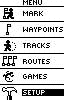
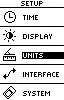
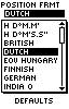
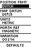
Mainmenu, Setup, Units, Position Format (set to Dutch), Map Datum (set to Dutch).
That is all. As told before: Position FRMT and Map Format go together. The software version in the Geko (juli 2003) does not allow a format different from 'Dutch' when the position format is set to Dutch. Here are some pictures of the screens you should see:
Magellan Meridian Gold, Platinum, Explorist 100 and Sportrak
(These numbers to type in seem to work also for the Magellan 320 I was told.)
From the Position Screen take Menu CoordSys and give an [enter].
There is a choice now: Primair of secundair, (primary is the good choice) [enter]
Gebr.rast. [enter]
Projectie => Trans Merc [enter]
Geograf. brdte vertrekpt = 52.15617N [enter]
Geograf. lte vertrekpt = 005.38763E [enter]
Volg > [enter]
Schaalfactor = 0.99990790 [cursor]
Eenheid tot meter omz = 1.00000000
Fout O bij vertrek = 00155000.0
Fout N bij vertrek = 00463000.0
Now you are ready and do an [enter]
Then the next things:
Datum kaart [enter]
primair of secundair [enter]
USER [enter]
Delta A (meters) = +0740.000 [cursor]
Delta F (meters) = +0.10037480
Delta X (meters) = +593.0
Delta Y (meters) = +0026.0
Delta Z (meters) = +0478.0
Opsl. [enter]
The "+" can be set with the up/down buttons.
There are software versions that mistakenly put 'Delta X' where 'Delta Y' should be standing. So you see two times the same 'Delta X'.
That's it! Some more tips and tricks, special for the Platinum and Sportrak (especially the difference between primary and secondary) are on this page
When you are in the "Positie Screen" use the right/left button to use the second screen with both coordinate representations one below the other (can be very handy!).
Remark: the calculations are done with a limit to the precision. So do not be surprised when a (computational) error of about 3 meters is found near the borders of the Netherlands.
Etrex Venture firmware 2.29:
Main Menu -> Setup -> Units
Position Format -> Dutch Grid
Map Datum -> Dutch
Garmin GPS V
Main Menu -> Setup -> Location -> Location Format (Dutch Grid)
Map Datum -> Dutch
The last one should be set automatically after the Dutch Grid choice.
The name in use on screen is 'RD'.
Garmin C60
Set your language 'Dutch' and you will have to do:
HOOFDMENU -> Instellen ->Eenheden -> Positieformaat
-> Ned. RD Grid
And that is all. The Map datum is set to Dutch. The representation of the position will be what you want it to be.
Benefon ESC! updated to R2002
Goto User Datum and User Grid.
User Datum:
DX: 593 meter
DY: 26 meter
DZ: 478 meter
DA: 740 meter
DF: 0.1003748
User Grid:
Longitude Origin: 5º23.258 East
False Easting: 155000
False Northing: -5316592
Scale: 0.9999079
MLR
Use the Dx, dy en dz as above. But you are asked for a 'A'and a 1/F.
These are:
A : 6377397.155
1/F : 298.34716
Mapsource
For the MapSource software in RD-grid you do the following:
Edit -> Preferences -> Position -> Grid: set to 'Dutch Grid'.
The Datum field will be automatically set to 'Dutch'.
That is all.
In older versions there is no built-in Dutch Grid so you have to it yourself by using the:
Edit -> Preferences -> System Defined Grid
Then the numbers should be like this:
User Datum (WGS84-local)
DX: 593 meter
DY: 26 meter
DZ: 478 meter
DA: 740 meter
DF: 0.1003748
Further more you have to have the following allright:
Edit -> preference -> position -> user defined grid format
User Grid
Longitude Origin: 5º23.258 East
(in decimal degrees notation this is 5.387633º East)
Scale: 0.9999079
False Easting: 155000
False Northing: -5316592
IMPORTAND REMARKS AND WARNINGS:
There is a problem when using User Grid if the Longitude Origin has more than four decimal digits.
The given figure will be rounded to 4 decimal digits, resulting is an easting error of up to 5 meters.
Figure out by how many meters the easting number exceeds the correct value, ans subtract that amount from the False Easting figure you have to put in.
For instance: with an easting error of 3 meters you should set the False Easting from 155000 to 154997 resulting in a shift of the map.
You can check your results with this program: CC40
